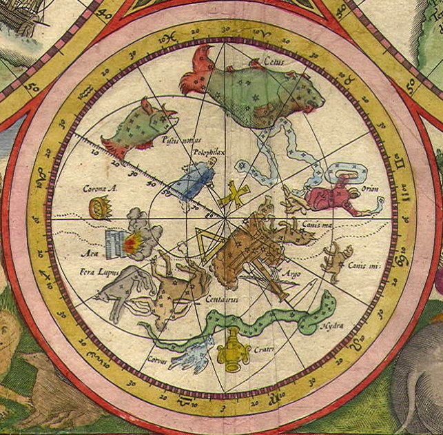
Polophylax and Columba on Plancius’s World Map of 1594

A small southern hemisphere chart inserted into the lower margin of Petrus Plancius’s world map of 1594 gives us a view of his constellations Polophylax and Columba, and also a misplaced southern cross. This chart is a view of the sky as would be seen on a globe, so constellations appear back to front from the way we see them in the sky. The chart is centred on the ecliptic pole, with the celestial pole left of centre. (Image: Leen Helmink Antique Maps.)
Petrus Plancius (1552–1622), the great Dutch cartographer, first introduced the constellations Polophylax and Columba in a small celestial hemisphere that decorated his world map of 1592 called Nova et Exacta Terrarum Orbis Tabula Geographica ac Hydrographica. They appeared again in 1594 on another world chart, above, titled Orbis Terrarum Typus De Integro Multis in Locis Emendatus, although on this version the constellation figures are not as detailed and lack some of the labelling of the 1592 chart. The hand-colouring varies from copy to copy.
Polophylax (here spelled Polophilax) was a short-lived invention representing a watcher or guardian of the pole, the southern counterpart of Boötes which the Greeks termed Arctophylax meaning bear-watcher or bear-guard. He is shown as a blue-robed figure above left of centre, with a Magellanic Cloud by his foot, in the area where Tucana, Hydrus, and Phoenix will now be found. Next to Polophylax is an imaginary Southern Cross.
Plancius’s information about this area came from a freehand sketch made three-quarters of a century earlier by the Italian explorer Andrea Corsali (1487–15??). Corsali’s diagram showed the southern cross, some other surrounding stars, and the two Magellanic Clouds. Plancius formed Polophylax from the group of seven stars at the left of Corsali’s sketch.
Polophylax and Columba (here labelled Columba Nohae, i.e. Noah’s dove) depicted on a small celestial hemisphere inserted in the upper right margin of Petrus Plancius’s world map of 1592. Between them lies an entirely imaginary southern cross, here given the alternative name Stauros from the Greek Σταυρός meaning ‘cross’ (the word is partially obscured due to bad printing). Only one surviving copy of this 1592 map is known, in the Colegio del Corpus Christi, Valencia.
Andrea Corsali’s sketch of the area around the south celestial pole showed the southern cross, top centre, with a tower-like pattern of seven stars to the left of it from which Plancius formed the constellation Polophylax. At right of centre are Alpha and Beta Centauri, the Pointers to the Southern Cross. Corsali’s diagram shows the sky as it would appear on a globe, as does Plancius’s chart at the top of the page. This printed copy comes from a book published in 1516. (State Library of New South Wales)
Without any positional measurements to guide him, Plancius evidently misunderstood the orientation and scale of Corsali’s drawing. It was not until 1597, when he received the first accurate observations of the southern stars made by the Dutch navigator Pieter Dirkszoon Keyser, that Plancius realized the celestial cross actually lay in the hind legs of Centaurus. In other words, the southern cross on Plancius’s southern charts of 1592 and 1594 is almost 180° from its true position, as well as being too large.
Once Corsali’s sketch is rotated to bring Crux into the correct position, and Polophylax is rotated by the same amount, it becomes apparent that the stars of Polophylax were actually part of Argo. Presumably Plancius realized this when he received Keyser’s observations and quietly dropped Polophylax, which was never seen on his charts or globes again. The large southern triangle on his chart beneath the keel of Argo was equally misplaced.
Columba, by contrast, does still exist as one of the 88 constellations officially recognized by the IAU. Plancius created it from stars around Canis Major that Ptolemy had listed in the Almagest as ‘unformed’. It can be seen on Plancius’s chart beneath the hind legs of Canis Major, next to the stern of Argo. It is unlabelled on the 1594 version, but on the original 1592 chart was given the name Columba Nohae (Noah’s dove).
© Ian Ridpath. All rights reserved