Rendlesham Forest UFO chase –
the route into the forest
ON OTHER PAGES
- Read the accounts of the eyewitnesses on the first night
- Why did the airmen think that something had landed in the forest?
- Did Jim Penniston touch a landed craft in Rendlesham Forest?
- Where was the landing site?
- Read Col Halt’s original memo
- Read the transcript of Col Halt’s encounter with the UFOs
- Was the flashing light really the lighthouse?
- What were the other lights seen by Col. Halt?
- What caused the landing marks?
- Were the radiation readings significant?
- Was it a hoax that got out of hand?
- Was the UFO detected on radar?
- The re-entry of the Russian Cosmos 749 satellite
Summary
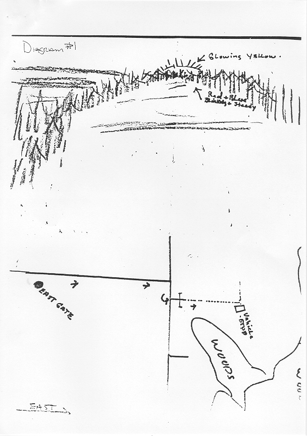
Shown in orange on the aerial photograph below is the probable route into Rendlesham Forest taken by security guards Jim Penniston, John Burroughs, and Edward Cabansag on the first night of the Rendlesham Forest UFO incident, shortly after 3 am on 1980 December 26, as based on their own written accounts.
Retracing their steps
In search of a light that had seemed to descend into the trees, the airmen drove eastwards from the East Gate of RAF Woodbridge, turned right onto a public road and then, after about 50 metres, turned left onto a forest track that is now largely overgrown by more recent planting (see the lower half of this sketch by Jim Penniston). They parked their vehicle at the end of this track and proceeded eastwards on foot towards some unidentified lights seen between the trees.
It should be clear from this map that they were heading in the direction of the lighthouse at Orford Ness, to the east. Forestry records show that the area through which they first walked (outlined in white below) was occupied by young Corsican pines that had been planted five years earlier; these would have been only around shoulder height, much shorter than the fully grown trees to the east, and hence possible to see over (Burroughs and Penniston were both over 6ft tall).
As the three men headed eastwards, the lights appeared to move between the full-grown trees in front of them and then out into the field beyond. According to the statement by John Burroughs, when they reached a fence at the forest edge they saw the lights ‘down by a farmer’s house’. This house lies on the opposite side of the field at a place called Capel Green. Two nights later, Col Halt also saw a flashing UFO in the same direction but was unable to identify it.
Chasing the lighthouse
The statements by Burroughs and Cabansag agree that they went past the farmhouse in pursuit of what they termed a ‘beacon’ light until, as Burroughs put it, ‘we could [see] it was comming [sic] from a lighthouse’. (The local police who were called out at the time made the same identification, as did US law enforcement officer Chris Armold.) Cabansag wrote: ‘Our route through the forrest [sic] and field was a direct one, straight towards the light.’ Burroughs and Cabansag both estimated that they went about two miles on foot from their vehicle but this is probably an exaggeration – the distance from East Gate to the landing site is almost exactly a mile.
Other coloured lights were also seen, but the descriptions are too vague for us to be sure where they were or what they might have been. Whatever their origin, they were still there an hour or so later when Armold went back out to the site with Burroughs, well after the supposed craft was said to have departed.
On the aerial view below, the orange dot labelled ‘landing site’ on the eastern edge of the forest is the spot where a triangle of indentations was found in the ground after daybreak later that same day (December 26). This is also the area where Col Halt took radiation measurements two nights later. To confuse the issue, Penniston subsequently claimed to have encountered a landed craft on the western side of the forest in the early hours of December 27 and made notes of it. But on his return to the forest for the 30th anniversary of the event in December 2010, Penniston came up with a new story: he said that the encounter happened in the southern part of the farmer’s field, near a row of trees that juts out. But this is still nowhere near the spot where the indentations in the ground were found the following morning.

Aerial view of the area of the Rendlesham Forest UFO sighting. The orange line shows the route from East Gate into the forest taken by the three witnesses in the early hours of 1980 December 26, shortly after a bright light was seen apparently plunging to Earth over the forest. The three men parked their vehicle in the region of the arrowhead and proceeded on foot to the east. The area outlined in white contained only young trees at the time. The point labelled ‘Landing site’ on the eastern edge of the forest is where marks on the ground and on the trees were found after daybreak later that day. In an on-camera discussion for German TV in 2009 February, Col Halt told me that he approached the site along the wider west–east track some few hundred yards to the south, finally turning left onto a north–south track between the trees. Click for a larger version. (Image from Microsoft Virtual Earth; annotation by Ian Ridpath)

For comparison, this is an Ordnance Survey map of the area as it was in the late 1970s, from the old-maps.co.uk website. The open area in the centre of the forest is readily apparent. This establishes that Penniston’s sketch map is quite accurate. Their route is marked in orange, and the so-called ‘landing site’ with a dot. See this video clip in which I retrace the airmen’s route from East Gate to the forest edge.
Content last revised: 2021 March
© Ian Ridpath. All rights reserved