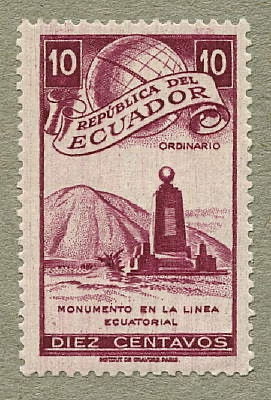
Ecuador 1949 – Equatorial line monument
This monument marking the position of the equator was built in 1936 at San Antonio de Pichincha, about 20 km (12 miles) north of Quito, the capital of Ecuador. Its construction commemorated the 200th anniversary of the arrival of a French-led expedition whose purpose was nothing less than to determine the shape of the Earth. To achieve this, they measured the length of a degree of latitude at the equator for comparison with the length of a degree measured near the poles. The results established that the Earth bulges at the equator due to its rotation, as Isaac Newton had predicted from his theory of gravity. The equatorial line monument is 10 metres high, its four sides are oriented north, south, west and east, and it is surmounted by a globe of the Earth. The monument appeared again on another Ecuadorian stamp in 1953, while the expedition itself was commemorated by a set of stamps issued in 1936.
In 1979 this original monument was moved 7 km west to the town of Calacalí and was replaced at San Antonio de Pichincha by a new one, of similar design but 30 m high. The location of this new monument is called Mitad del Mundo (Middle of the World), although accurate measurements from GPS satellites show that the true equator passes about 250 metres to the north of it.
SG number
Face value
Colour
901
10 c
Purple
